| |
 |

There's Gold in Them Thar Hills
You can wander through high alpine tundra just two hours from Anchorage.
Hatcher Pass is 3,000 feet above
sea level and features the Independence Mine State Historical Park.
Now a popular recreation area, this mine was in operation starting
in 1906.
Millions of dollars worth of gold from 10 miles of tunnel came from these mines.
You can see the old buildings, pick berries,
and photograph tiny wildflowers. |

Independence Mine Is Historic Site
Alaska State Parks has displays at Independence Mine in Hatcher Pass.
The road up to Hatcher Pass is steep and scenic.
At its height, there were 27 buildings on 1,350 acres of
claims, making this the largest operation in the Willow Creek Mining District.
See the assay office, bunkhouses and other buildings. |

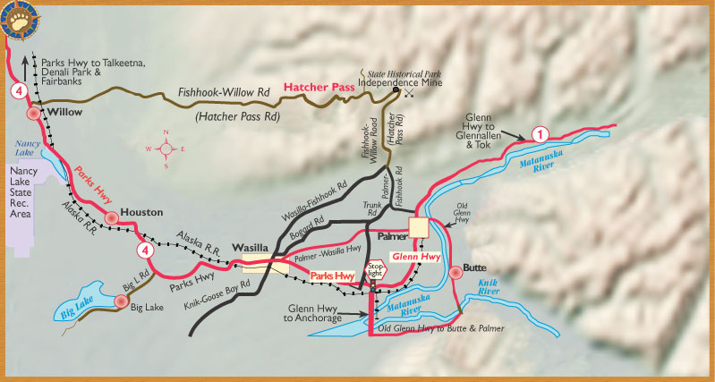
Three Roads to Hatcher Pass
 Three roads go to the mines at Hatcher Pass. What do they have in common? The word "Fishhook." Just look for
the word "fishhook," and
you'll be on your way. Three roads go to the mines at Hatcher Pass. What do they have in common? The word "Fishhook." Just look for
the word "fishhook," and
you'll be on your way.
1. From Palmer, take the Palmer-Fishhook Road.
2. From Wasilla, take the Wasilla-Fishhook Road.
3. From Willow, take the Fishhook-Willow Road.
What do the mines at Hatcher Pass have to do with fishhooks? In 1906, gold was struck at Fishhook Creek. |
 |
|
|
Q: How far is Hatcher Pass from Anchorage?
A: Only 67 Miles... Perfect for a day trip.
It's a Gold rush camp. Lots of mine buildings. Interpretive signs and visitor center. Guided tours. Easy trip
from Anchorage.

|
|

WHEN YOU CAN'T TAKE THE COMPANY OUT OF THE TOWN: ALASKA MINING HISTORY
The Alaska gold rush brought large numbers of inexperienced gold seekers – alone and in small groups of
friends – to the state.
 Big corporations held back while these miners (at considerable risk to themselves) explored the country. Once
high value claims were established, investors banded together to buy them out. They built company towns. Big corporations held back while these miners (at considerable risk to themselves) explored the country. Once
high value claims were established, investors banded together to buy them out. They built company towns.
Some of these company mining towns still exist: Ester, the Kennicott
Mines, Crow Creek Mine – and the Independence Mines at Hatcher Pass.
Click here for a map of Gold Rush sites in the Kenai Peninsula
and on the Parks Highway.
|
|
HARD ROCK TRAIL
Follow this historic trail to the base of the mine taiings, and up to the mine shops and 2,000 foot level.
SUMMIT LAKE TRAIL
Two miles past Independence Mine you’ll reach 3,886 foot Hatcher Pass
Summit. Follow the trail around Summit Lake for great views of the
Susitna Valley and the Alaska Range.

|
|

Here you can find out all the latest news about the park that draws
many visitors to Hatcher Pass; or dig deeper into Alaska's gold rush
history. Brought to you by the Alaska Department of Natural Resources
|
|
 |
|
