| |
 |

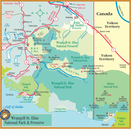
Wrangell-St. Elias National Park
Not as well known as Denali National Park, but really big. And quite unlike Denali.
In Denali, travel is highly
regulated. Here, access is by car or van along two dirt roads – the Nabesna Road in the north, and the McCarthy Road to the south.
You
can also get here by small plane. The park borders are the Copper River, Canada, and the Gulf of Alaska. The Kennecott copper mines are
the high point of any visit.
(Photo, Robert Gaucher) |
 Friends in Low Places Friends in Low Places
There
was nothing hard-scrabble about the Kennecott mines. Everything was
perfectly up-to-date. The workers had hospital facilities. There was a
laundry. Fresh fruits and vegetables were railed in. The managers lived
in fancy housing and had small children who went ice skating and had
tea parties
But when it came time to let off steam, raucous McCarthy was just down the road – full of booze
and good times. |
  McCarthy McCarthy
McCarthy began as a homestead in 1906, when John Barrett speculated the building of the railroad would need an outfitting
town. McCarthy, Kennecott and Chitina all wasted away with the closing of the mines. Steel from the old rails was hauled
to Valdez to be shipped “Outside.”
But
ironically, many of the rails slid into Valdez Harbor during the Great Alaska Earthquake in the spring of 1964. |
 Bringing Back the Old Town Bringing Back the Old Town
It’s a hard job resurrecting a place as isolated as McCarthy. But local people are doing it.
Here’s
Ma Johnson's Hotel, a famous McCarthy landmark.
(Photo, Ma Johnson's Hotel) |

Hop A Shuttle Between McCarthy and Kennicott
The footbridge at the end of the McCarthy Road isn’t wide enough to accommodate your car.
So you’ll park your car near the bridge
and walk across to the McCarthy & Kennecott side of the river.
Once
you’re on the other side, you’ll find that there are local shuttle
services, for a reasonable fee. They travel in a loop between the
footbridge, McCarthy, and Kennecott all day long. The van will drop you
off and pick you up.
Or, you can ride your bike – or walk the half mile to McCarthy or 5 miles to Kennecott. |
 Mt.
Wrangell Is Alaska's Largest Active Volcano Mt.
Wrangell Is Alaska's Largest Active Volcano
Of the 15 highest peaks in Alaska, 12 are in Wrangell-St. Elias Park.
Mt. Wrangell is the largest active volcano in Alaska. On cloudless
days, a small puff of steam can often be seen rising from the north
crater near Wrangell’s summit.
Before the Great Alaska Earthquake in 1964 (which did great damage to Anchorage, Valdez, and Portage) the west crater on top of Mt. Wrangell was the most
active. But after the earthquake, the north crater became more active.
There
is a kilometer of ice on top of Mt. Wrangell. Its mean annual
temperature at the summit is 21 degrees below zero. In spite of the
extreme cold, over 100 million cubic meters of ice have melted on the
north crater since 1964.
One
meter below the crater’s surface lies boiling sulfuric acid.
During
the days of the gold rush, early miners (who chronicled every day of
their exasperating adventures with early Kodak cameras) took photos of
Mt. Wrangell billowing big clouds of dark steam.
Scientists are now probing to see what happened inside the mountain after the 2002 Alaska
earthquake – and the big tsunami-generating earthquake in Asia. |

Bearfooting in Wrangell-St. Elias National Park
About the Rivers
All of the rivers in this part of Alaska are very cold. The National
Park Service advises you to cross the rivers at their widest, slowest
moving channels. Keep your boots on. And tie in if you can before
entering the water. Some rivers are “floatable.” Contact the visitor
centers for advice about guides and outfitters.
Camping & Lodging
There's an official park campground at Kendesnii Campground on the
Nabesna Road, at Mile 27.8. Keep in mind the Nabesna Road is located at
the Park's northern access point, about halfway between Glennallen to
Tok. And you don’t need a
permit for camping – or for backpacking. On the McCarthy Road you’ll
pass by cabins, hotels, cottages, and some camping facilities. There’s
camping at the end of the McCarthy Road at the Kennicott River.
Park Cabins
Some public use cabins are reservation only: Viking Lodge Cabin (free),
Caribou Creek Cabin (free), & Esker Stream Cabin (which charges a
fee). All other public use cabins are first come, first serve. For
reservations visitors can call: 907-822-7253.
Water
There are outhouses in the Kennecott-McCarthy area, but drinking water can be a problem. Bring some with you.
 Getting Around Kennecott Getting Around Kennecott
The road to McCarthy ends at the bridge, half a mile from town.
Kennecott is 4 miles up the road. There is a shuttle service, or you
can walk or bike to the mines.
Walking Around
During the summer, the Kennecott Visitor Center has ranger programs and local
businesses give glacier and history tours. If you’re not on a tour, you
have to stay out of the mine buildings. There is a self-guided walking
tour of both McCarthy and Kennecott. Ask for a brochure.
Flightseeing
The mountains are often visible here. You’ll find the aerial views of
the Kennecott Mines and buildings just as spectacular as the mountains
and vast ice fields. |
Wrangell-St. Elias National
Park Hotspots
Copper Center
The main park visitor center is in Copper
Center at Mile 106.8 Richardson Highway. Stop here for historical and natural history displays, including
the park film.
There are interpretive programs in the summer.
Nabesna
A beautiful log cabin visitor center at Mile .02 Nabesna Road. They have
advice on Nabesna travel, maps and interpretive programs. The facility here is known as the Slana Ranger Station.
Chitina
In downtown Chitina at Mile 33 Edgerton Highway. This station is expected to be open on an irregular
basis this summer.
McCarthy Kiosk
A small, semi-enclosed booth about a mile before the bridge at the Kennicott River. This
has outdoor bulletin boards and information.
Kennecott Visitor Center
The
Kennecott Visitor Center is in the historic store downtown, and
provides trip planning, bear canister checkouts, interpretive programs,
and a film on the history of Kennecott -- in the summer only.
|

Exploring the National Park
Don’t underestimate Wrangell-St. Elias. Take advantage of the expertise of local backpacking and mountaineering
guides, air taxis, and river rafters.
Never head into the wilderness unprepared. And let people
know where you are going. Get information from the Wrangell National Park Visitor Center.
(Photo, Robert Gaucher) |
The Park Service is Preserving
Kennecott's Buildings
 The
National Park Service has spearheaded efforts to preserve these mine
buildings. In recent years, preservation efforts have focused on
stabilizing the existing structures. The
National Park Service has spearheaded efforts to preserve these mine
buildings. In recent years, preservation efforts have focused on
stabilizing the existing structures.
|
|

Please Respect Private Property
Once you arrive, please note that you are in an actual town, and respect local privacy and property. It
is especially important that you protect fresh water sources.
And don’t enter buildings without a guide. |
|
+ Activities + Things to Get
+ Where to Stay + Where to Eat


MCCARTHY & KENNICOTT BUSINESSES
 Getting There is Half The Fun Getting There is Half The Fun
The
McCarthy Road is 60 miles long. Rail spikes can surface through the
washboard (dramatically but infrequently), and rain can make the road
slippery.
It’s 125 miles from Glennallen to McCarthy. The park service recommends driving 20 mph. This means a 3-hour
one way trip from Chitina. Take a spare tire.
The park service publishes a McCarthy Road guide and a roadside geology guide for
the McCarthy Road.
ROADSIDE ATTRACTIONS
• Mile 10 McCarthy Road (Strelna Lake) Access to half-mile hiking trail and stocked rainbows and silvers.
 • Mile 10.7 (Silver Lake) Stocked rainbow
trout. Private campground. • Mile 10.7 (Silver Lake) Stocked rainbow
trout. Private campground.
• Mile 17
(Kuskulana Bridge) 525 feet long, 238 feet above the river. Built in
winter of 1910. Mile 29 (Gilahina Trestle) A dramatic abandoned railway
trestle left behind by the great Copper River & Northwestern. Snap
a photo! It's great!
• Mile 59 (National Park Service Kiosk)
Information on trails, maps, day-use only parking. No camping.
• Mile 60 (Kennicott River) You must
park here. Or turn around. There is a fee for camping and parking on
private land. Pit toilets, but no water... welcome to Real Alaska.
Cross the footbridge & walk half a mile to McCarthy, or wait for
one of several shuttles.
|
|
 How far is Kennicott from Chitina anyway? And how is it spelled? How far is Kennicott from Chitina anyway? And how is it spelled?
60
miles from Chitina
So which is it - “Kennicott” or “Kennecott”?
The national park service says the glacier and river are “Kennicott”
with an “i”. And the mill and town are “Kennecott” with an “e.” A minor
difference in spelling? Hardly. Wars have been fought over less. In
other news, the Kennecott company now runs a huge Utah open-pit copper
mine. |
|
Wrangell-St. Elias National Park
 Size: 13.2 million acres Size: 13.2 million acres
The Alaska, Wrangell, Chugach & St.
Elias mountain ranges converge here. Six times bigger than Yellowstone, the park includes 18,008 foot Mt. St. Elias, the U.S.’s
2nd highest peak. Canada’s Kluane National Park is next door. Home of Kennicott & McCarthy. |
|
EASY McCARTHY TRAIL
There is an easy half-mile trail which follows a small section of the original Valdez-Fairbanks Trail at the National Park Headquarters in Copper
Center.
TRAILS IN THE PARK
If you want to hike in the park itself, you should ask at any of the
park visitor centers. You should be aware that there is no system for
monitoring individual trips. The best advice is:
1) Ask before setting out.
2) Get good maps.
3) Write out a detailed hiking plan including when you will
return, and leave it with a responsible person. |
|

MINING HISTORY: LEAVING THE DINNER TABLE
 The
Kennecott Copper Corporation started these copper mines deep in the
Alaska wilderness in 1911. The mine was producing at a good rate right
before the beginning of World War II, when it was abruptly closed and
the workers were shipped out. The
Kennecott Copper Corporation started these copper mines deep in the
Alaska wilderness in 1911. The mine was producing at a good rate right
before the beginning of World War II, when it was abruptly closed and
the workers were shipped out.
Some say that the closure was so sudden that tables were left still set for dinner. The mine was never reopened. |
|

Wrangell-St. Elias National Park
Wrangell-St. Elias National Park remains almost completely wild and is
a major attraction for experienced hikers and outdoors enthusiasts. Its
main entrance is the McCarthy road. Read all about it at the NPS
website. |
|
|
