
 |
Still Country, Still Cool
When something needs to be done you don’t wait for somebody else to do it here. You step up to the plate and pitch in. The local newspaper is the Copper River Record. This is Fred Ewan of Gulkana Village, demonstrating the proper way to preserve fish. |
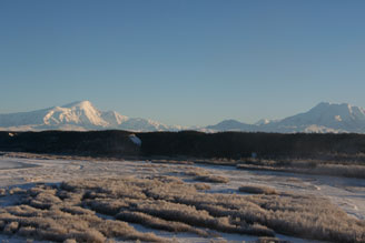
Over 20,000 years ago, the area now drained by the great Copper River was a massive lake, covering 2,000 square miles. In nearby Tangle Lakes (on the Denali Highway) signs of human life go back 10,000 years. Scientists speculate that ancient people used the northern mountains as a migration route to what is now the “Lower 48” and South America. In some parts of the region, the ancient shorelines of the lake are still clearly visible at around the 2,000 foot level. |
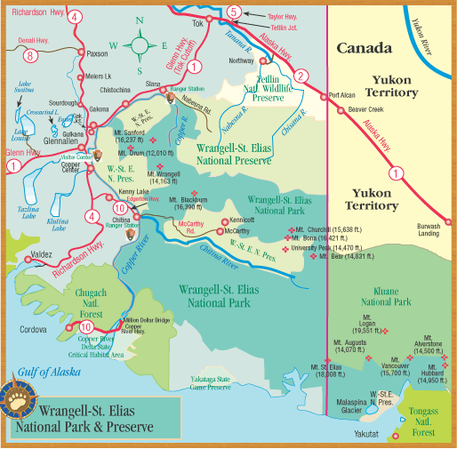
Salmon from any Copper River Valley river, no matter what its name, are Copper River salmon. For example, a Tazlina River or Gulkana River salmon is still a Copper River salmon. Here's a map showing the major tributaries of the Copper River. |

 The Copper Valley was a Huge Lake
|

Paxson, which is little more than a roadhouse and a cluster of buildings surrounding a highway maintenance camp, was, at that time, the only access to the 135-mile long Denali Highway. And the Denali Highway was the only way to drive to Denali Park (though you could get there by train.) The original 1906 Paxson Roadhouse was a tiny cabin and two tents. |
Officially part of the Glenn Highway, the Tok Cutoff starts at Gakona Junction and heads northeast to Tok. It skirts the Wrangell Mountains and parallels the Copper River. The cutoff connects the Tanana River region to the Copper Valley. It passes by a number of Athabascan Indian villages. The Nabesna Road, at Mile 64, leads into the northern end of Wrangell-St. Elias Park. |
Sometimes said as a joke, but for rural people, the importance of the salmon migration up the Copper River and its tributaries cannot be underestimated. For centuries, Copper River salmon have provided sustenance for people living in the Copper Valley. They are a far more dependable food source than the large mammals like moose and caribou, whose populations fluctuate. Excellent protein, salmon are heavy with omega-3 fats for their trip from Cordova north. Once caught, they are also relatively easy to preserve (even before freezers were invented) by smoking and drying. |
Three Rivers Meet Near Gakona
The Copper River drains the whole region, and runs all the way to Cordova. The silty Gakona River, which starts north, in the Alaska Range, meets the muddy, many-channeled Copper River at Gakona. There is a great viewpoint of this confluence at Mile 1 Tok Cutoff. The Gulkana River is a clearwater stream, full of grayling and salmon. It comes south from Paxson Lake. At the turn of the century, there were two roadhouses in this area, one at the Gulkana River (“Santa Claus Lodge”) and the other – still here today – is Gakona Lodge, on the banks of the Gakona River. + Here's a map showing these three Gakona rivers, plus a lot more. |
 
Tough Stuff: The Past and Future of Urethane Foam During the 1950’s, 60’s and 70’s, many future Alaskans left their homes in the “Lower 48” and came north. Once here, the arduous task of building a home from scratch began. The first problem was where to stay while building. The second problem was how to insulate your new house. So in the 1970’s, Alaskans discovered the miracle of urethane foam, a wonderful but doubtful-looking insulation that can be sprayed over any surface. Cabin 1 was completely foamed to stop the flow of air through the log walls. Cabin 2, the log cabin in Glennallen at the Hub, has a urethane roof covered over with grass and sod. It has never leaked. |
The village of Chistochina has grown up around the Chistochina fish camps, where people use fish wheels to harvest Copper River salmon. Today it’s home to the Cheesh’Na Tribe. About 60 people live here. This photo shows community elders Ben Neeley and Bill Joe. |
This is a smaller facility than the one in Copper Center.
You can go on a botany walk from the ranger station on request. Weather, staff and trail conditions permitting they offer a natural history walk for people interested in seeing the country. They have a Kids’ Corner at the visitor center and offer a Jr. Ranger Program for kids under 12 years old. They also have a book store. |
Slana, located in the harsh wilderness off the isolated Nabesna Road, was the very last place in America to be homesteaded. By 1986, when homesteading finally ended in Alaska, 800 pieces of land had been staked in Slana. But below-zero winters, tent homes, and a lack of jobs eventually drove off over 70% of Slana’s hardworking, hopeful residents. Only 100 homesteaders actually got patents to their land. |
The road to Nabesna (at Mile 60 Tok Cutoff) leads into Wrangell-St. Elias National Park’s northern entrance.
The scenery along the Nabesna Road is spectacular, and there are several good grayling lakes. Nabesna, an old gold-mining town, is 46 miles up the road. The Nabesna Mine is privately owned. This road was built in 1934 by the Alaska Road Commission so they could haul gold ore to Valdez. Today, people drive the road because it takes them up into the headwaters country of the Copper River and Upper Tanana River. Hiking on the lower trails can be very muddy and buggy. Past Mile 36, the trails get better as you get into the high country. You need to get a permit if you’re going to use an ATV (all-terrain vehicle). There are no gas stations up the Nabesna Road, so be sure to fill up before you go. |
There are only two road routes into America’s largest park, Wrangell-St. Elias National Park. The northern entrance is at Slana where the 46-mile 2-wheel drive gravel Nabesna Road starts. (The southern entrance takes you to McCarthy and Kennicott.) Beyond Mile 29 on the Nabesna Road, there are 3 creek crossings. Check at the ranger station in Slana for road conditions and to see maps of the park. |
Athabascan Indians Were Skilled Traders in a Good Place The language spoken by the Athabascans who settled in the Copper River Valley is closely related to some Indian languages spoken in the Southwestern United States.
Also well known as skilled traders, due to their location on major trade routes, Copper Valley Natives were important carriers of goods across Alaskan cultures. The Athabascan people here now create intricate bead and leather work. Around 20% of the Copper River Valley’s population is Athabascan at this time. Young children from the region are taught Native dances, and respect for traditional Native culture is strongly rooted here. This is Coleen Charley, getting into the spirit of life in the shadow of the Wrangells, at a local Potlatch. |
Lena Charley (right) of Chistochina typifies the rugged, hardworking Alaska lifestyle. A life-long dog musher, she has competed in many major dog races, even after becoming a grandmother. She’s a beadworker and skin sewer. And, she won the Alaska Federation of Natives’ annual hunting and fishing award for her ability to provide food from the land. |
Mentasta matriarch Katie John’s name is synonymous with a landmark Native subsistence rights legal battle, which she won. In 1984, she sued the federal government after being denied use of her family’s traditional fishing grounds near Mentasta. Katie John lived to be over 90 years old, and cheerfully raised her own 14 children and 8 others. Don't Mess With Katie! |
In November 2002, one of the strongest earthquakes ever recorded in North America pulled open the Tok Cutoff near Mentasta leaving holes 12 feet deep. The epicenter was in the Alaska Range between Cantwell and Paxson. The earthquake seriously damaged homes, wells and roads in Slana and Mentasta. The Tok Cutoff was completely closed, and the Richardson Highway between Paxson and Delta was closed. Notice the tracks of the 18-wheeler that came to an abrupt halt when the road cracked open beneath his wheels. Fortunately, nobody was killed in the Alaska Quake of 2002. |
Moose nose is a delicacy in the north. It tastes like beef tongue, and is a rich, highly-textured meat. Locally, moose stew is made by cutting up the meat in very small pieces and boiling it with vegetables into a rich, hearty broth that can be fed to a large group as an appetizer before dinner. |


 Less than a mile from the junction, on the left, is the hand-hewn log Slana Post Office.
 The
Athabascans in the Copper River Valley were adept at fashioning copper
implements, which they traded with coastal Natives. They lived a
semi-nomadic life, based on the cycles of fish and game in the region.
The
Athabascans in the Copper River Valley were adept at fashioning copper
implements, which they traded with coastal Natives. They lived a
semi-nomadic life, based on the cycles of fish and game in the region. Dog Musher, Hunter, Artist...
 Huge Quake Hit Mentasta in 2002
  Moose Nose Soup
|
|||
|
|||
|
|||
|
|||
|
 About the Copper River...
  Pop:
3,500...
Pop:
3,500...

